Hello, everyone! Hopefully if you're reading this you've already read my most recent blog, which I think is one of my best and is what I had in mind when I decided to extend this blog into the summer. My summer so far has been pretty eventful, but nothing really stood out by itself as blog worthy; however, at Lindsey's recommendation, I've decided to talk a little about what I've done this last month. After all, it wasn't too long ago that people kept regular diaries. It is good for the memory and as self-reflection to keep an account of what one has done. Strap in, because here comes a long one.
This summer, other than working hard at Los Alamos and working on my Master's thesis, I've been spending my spare time learning new songs on guitar and reading books. So far this summer I've read "Stalin and the Bomb", by David Holloway, a book I picked up at Goodwill 5 years ago and finally got around to reading. While I loved this book and thought it was incredibly informative, I would definitely not recommend it to anyone not wanting to read an in-depth book historically and technically. A light read, it is not. I just got done reading "One Man's Wilderness: An Alaskan Odyssey", adapted by Sam Keith from Dick Proenneke's journals, which was lent to me by my good friend and brother Eli. Dick Proenneke was a handyman who loved Alaska so much he decided to build his own cabin from scratch in the wilderness. The diaries cover his first 16 months spent in the Twin Lakes region of Alaska building his cabin and living through his first winter in the wilderness, and his reflections and insight are heartwarming. While the prose is probably not authentic to Proenneke's, as his friend Sam Kieth did enough editing to warrant lead authorship credit, his train of thought lends itself to a thoughtful, introspective man who just wanted to live a no-frills life. He didn't seek out solitude as a hermit or loner, he just didn't mind it and viewed it as a necessary evil for living in the pristine wilderness. I would highly recommend this book and the
documentary based on his personal footage (watch this ASAP since it likely violates copyright laws and has only evaded reprimand due to its low view count). I am now reading the famous Adventures of Tom Sawyer in an attempt to read more classic fiction. My reading repertoire has mostly been historical books written by historians, journalists, or in the form of journals or diaries, so I thought it would behoove me to get more in touch with famous works of fiction.
Mitchell Trail, a.k.a., Caballo Pt. 1
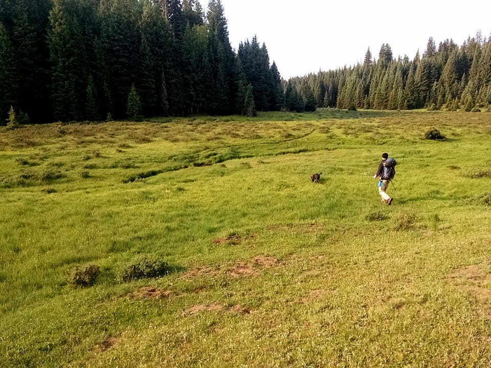
Anyway, onto how I've been spending my time this summer. The first weekend I was in Los Alamos, Memorial Day Weekend, I made plans with a friend of mine from NC to go on a two-day backpacking trip. Unfortunately, the fates decided otherwise, so these plans were scrapped. Instead, I elected to go on a day hike. Los Alamos is an excellent town for hikers and bikers. The Mitchell Trail begins, essentially, a couple blocks away from my house and has opportunities for hiking, biking, and backpacking. The trail is famous in the area as the gateway to the "Los Alamos Natural Arch", which Lindsey mentioned in her blog, and as being the starting point to many a trail run. It was created in the 70's by a Boy Scout trying to make the transition to Eagle Scout, but he unfortunately passed away "of an unexpected illness" before seeing its completion. My goal was to make it to Caballo Peak, one of the tallest peaks within hiking distance from Los Alamos, but I misread the trail description as 10 miles round trip, when it was really 10 miles one-way. I hiked about 5 miles, looked at where I was on the map, realized my mistake, and turned around.
 |
| The story of the Mitchell Trail |
 |
| My intended target in the foreground |
One unfortunate part about this trail is that it punctuates how bad the fire damage is around here. It is hard to believe that this entire area used to be wooded, but the Cerro Grande fire in 2000-ish burned down much of this area and even caused some damage to the town of Los Alamos. However, many of the excellent views would have been obscured by trees, so I guess there is a silver lining.
That night I did manage to get in a camping trip with my friend. We drove into the Jemez and, after a lot of driving due to unexpected road closures, ended up finding a nice camping spot just off Forest Road 10. As you can see, the view was superb, but, unfortunately, I forgot water, so I ended up being quite dehydrated and had no way to make my coffee, tea, ramen, oatmeal, etc. So, the menu for the evening was beer and granola bars.
 |
| Credit to Camen for this excellent picture |
San Francisco for UPR 2017
Two weeks later I was on my way to Walnut Creek, CA, for the UPR 2017 conference, where I was presenting. Walnut Creek, CA, is a bay area city that is home to innumerable luxury car dealerships and Asian restaurants. In fact, every day of the conference I had Asian food for dinner. Every meal I had except for the lame, overpriced Chinese buffet at the Marriott was delicious. Because the conference ended early Thursday, I decided to take the train into San Francisco to cram in some sightseeing. When I was younger, maybe 10, my parents, brother, and I visited the bay area for a vacation. My memory is hazy, but I remember going to Napa Valley, the redwoods, Coit Tower, Ghirardelli, Chinatown, and Fisherman's Wharf, so I had some idea of what typical low-cost/free tourist things I could knock out in a long afternoon. I managed to go to Coit Tower, Chinatown, Lombard Street, Ghirardelli Square, and Fisherman's Wharf all in one afternoon without taking a single cab! However, San Francisco is famously hilly, and this wore me to the point where I was miserable taking the crowded train back because there was standing room only.
 |
| If you have never seen The Room (2006) I recommend it. It's a trip, and seeing this sign put a huge smile on my face. Apparently, the director/producer/writer/lead actor of the movie owns this building. |
 |
| Way too foggy to get a good picture of the Golden Gate Bridge, but at least I got one |
 |
| Alcatraz |
 |
| San Francisco on a cloudy day |
 |
| Taking photo-taking tips from my mom |
 |
| I really hope they don't actually use this chocolate, because the entire time it's doing its thing there are people staring down into it |
 |
| This area reminded me of Christmas because of its homemade hot chocolate aroma |
 |
| My overpriced but well-deserved and delicious sundae from Ghirardelli |
 |
| Lombard Street |
 |
| Lombard Street from the bottom |
 |
| Coit Tower. I don't remember there being plexiglass in front of the windows at the top from when I was younger, so someone must have ruined it for everyone. |
 |
| The foggy view from Coit Tower |
My lunch was in Chinatown at Hunan Home's Restaurant. I ordered the Hunan chicken, which was good but not spectacular. The staff was polite, though, and the restaurant was clean. I went into another restaurant before this one but could not figure out how to order food, so I left. I ordered bean curd with my meal since it was in the same section as egg rolls, thinking it would be a somewhat similar dish. It turns out bean curd is literally just unseasoned tofu. Not wanting to waste food or carry a bag of food around with me the rest of the afternoon I begrudgingly ate the flavorless appetizer meant for 4. I wanted to go to a bakery to stock up on Chinese goodies, but I had no cash! I will have to wait until I'm in Chicago's Chinatown for my annual trip to get Chinese baked goods.
 |
| My sad bean curd |
 |
| Hunan Chicken |
Mount Taylor
When I returned I went straight to Gallup to visit my good friend and fraternity brother Eli. However, I couldn't pass up the opportunity to get lunch at Frontier and get one of their famous sweet rolls. Frontier is probably my favorite restaurant in Albuquerque, and I used to go, not exaggerating, 2 or 3 times a week when I lived on campus to avoid the terrible campus dining. Frontier is a great place to just hang out, even if you're by yourself. It's nice to be around all the hustle and bustle and to people watch.
 |
| Frontier sweet roll |
On my way to Gallup I decided to (sort of) fulfill a goal I've had, which is to climb Mt. Taylor. Mt. Taylor is a prominent peak in western NM which is sacred to the Navajo people, as it marks the southern border of their traditional homeland. It is a dormant volcano that once rose to over 20,000 feet, but now sits at around 11,300. On clear days it can be seen easily from many of the higher areas of Albuquerque. Since it was somewhat late upon my arrival, rather than actually hike up it, I decided to drive up to the nearby La Mosca Lookout. The drive was relatively easy until the very last part, but this is exactly why I bought a Jeep! This would probably be classified as an easy drive, but it was still pretty harrowing to look out the side of my car and see a steep decline. When brake failure=death you tend to keep one hand on the parking brake, just in case.
 |
| Mt. Taylor is the peak on the right |
 |
| View to the west |
 |
| One can see a lot of recognizable features from this peak. It is funny to see familiar features from a completely different angle. Cabezon Peak could also be seen from here, but the camera could not pick it up well with all the haze from the wind. |
 |
| View towards Grants (west) |
 |
| View east. The Sandias were visible from here, and Albuquerque probably would have been, too, if not for the haze, which also hid the mountains from the camera. |
 |
| A view of where I came from. If you squint you can see the work truck on the way down. |
 |
| Abandoned building. There was a work crew up there working on the antennae. Imagine that commute! |
 |
| The road to the lookout |
That basically covers my last month! My next two weekends will be mostly free, so I will probably take the opportunity to get out and explore, even if it's by myself, so stay tuned for more blogs! Lindsey is visiting me the 15th, so look at her blog for that adventure! Thank you for reading, and, if you didn't read, I hope you at least looked at all the nice pictures I took.