здравствуйте, readers! I sincerely hope you are all having an excellent summer. I can't believe how fast it's flying by! I feel like I just got here, and I only have 2 and half weeks left before I head back. You'll notice my blog has a bit different of a format. This was mostly to make the large images appear better.
Two weekends ago Lindsey visited, and our adventures are detailed in
her blog, which I recommend reading. This weekend, my "Friday On" week (I work 9 hour days, so every other week I get a Friday off), I had no plans. I had flirted with the idea of going camping and hiking up
Chicoma Mountain, the highest peak in the Jemez, but the over 2 hour drive and impending rain kind of put me off that plan. I could have hiked it without camping, but the trail is less than 1.5 miles long, and 4+ hours of round-trip driving just dissuaded me. So what did I do with my weekend? I saw Dunkirk, which I would highly recommend, but be forwarned, it is not Patton or Band of Brothers, it is more like a survival movie or a horror movie. What else did I do? Read ahead to find out 😀
Cerro Grande
Saturday morning I drove into the Jemez and climbed
Cerro Grande, a 10,207' peak on the southeast side of the Valles Caldera. The trailhead is very easy to find, as the signage is pretty good around it, and it is only 15 minutes or so from the West Gate of Los Alamos National Lab. Cerro Grande is the highest point in Bandelier National Monument, but, despite being a part of the monument, it does not appear to be a fee area. The mountain lends its name to the famous 2000 Cerro Grande Fire, which devastated the surrounding area, including much of the area immediately around Los Alamos. The mountain itself wasn't damaged much, but the 2011 Las Conchas Fire did damage it.
I would rank this hike as easy-moderate. The
National Park Service lists its one-way length as 2.3 miles and the elevation gain as 1200'. I think it took me a little over an hour one-way to do the hike. It took me a hot minute to get a good pace, though, because I eyed two creatures lurking in the grass, and my survival instincts kicked in. I kept stopping to scan the grass to see if I could figure out what they were, and eventually I got a good enough look to see that they were just coyotes.
 |
| USGS Marker, I guess they forgot to include the elevation! |
 |
| Cairn marking the summit |
 |
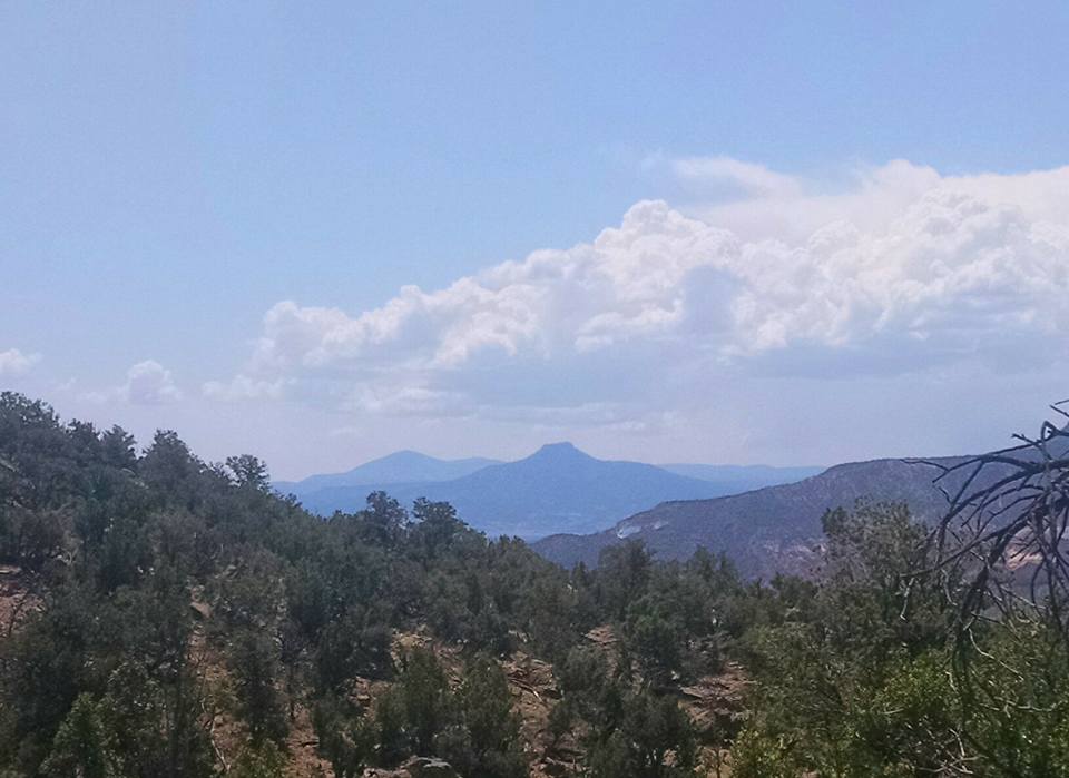
| I'm fairly certain the tall plateau in the distance is the San Pedro Parks, featured in a previous blog |
 |
| Great view of the Caldera with Redondo Peak in the center. You can see the road on the left. |
 |
| View south. I'm not sure if the camera captures it, but I could see so far south that Ladron Peak and possibly even the Magdalenas were visible. |
 |
| View towards Pajarito Mountain and the burn damage |
 |
| View towards the Sangre de Cristos |
 |
| Panorama with my new phone. I hope the pictures look better, because the camera on this phone is much, much better. |
 |
| Trail on the way down, the yellow diamond marking the path is visible on a tree in the distance |
 |
| Trailhead |
St. Peter's Dome
After getting back to the trailhead, it was just past 10 AM, and I had a lot of day ahead of me to kill. I decided to hike
St. Peter's Dome, a prominent, but small, peak straddling the edge of the desert and the mountains. This peak will probably not end up being painted or photographed, as it's a pretty ugly peak, but from Los Alamos and White Rock it is prominent and recognizable. The real draw was that I knew a 4WD road that went right to it, so I thought I could squeeze in a nice view without much work. The name is a mystery, and none of my research has turned up any definitive source. The book "The Mountains of New Mexico" says that its name comes from its likeness to the dome on St. Peter's Basilica in Rome. I would say that this is definitely possible, and perhaps when it had more trees this was less of a stretch of the imagination. A running theme you've probably seen with the Jemez is that recent forest fires have destroyed a lot of tree cover, and St. Peter's Dome is no exception. St. Peter's Dome lends its name to the surrounding Dome Wilderness, the smallest wilderness in NM, and this wilderness borders the Bandelier Wilderness. Both wildernesses were basically de-treed in a 1996 fire. While I would have loved to see this area with trees, the barren landscape lends an alien feeling to the wilderness.
Getting to St. Peter's Dome is relatively easy. Not more than 200 yards west of the Cerro Grande trailhead is the forest road that turns off towards St. Peter's Dome. This is a 4WD road, but in good conditions I doubt you would need it, and I ended up parking next to a 2WD only Honda CRV. High clearance would be recommended, but one could definitely make it to the official trailhead without it. Getting to the unofficial trailhead might be a challenge, but it could be doable. Signage is good enough to not need a map, but when you get to a sign that says "St. Peter's Dome Trailhead" you want to turn left and keep going if you want to take the unofficial trail. The official trailhead is a 6.1 mile out-and-back, which I certainly did not have the energy to do. To take the unofficial trail, take that left and drive up until you get to a locked gate. From here, get out of your car and hike the rest of the 1.1 mile on the Forest Service road to the peak. The view here is incredible, and you get a good look at Cochiti Lake. The main 4WD road actually eventually hits Cochiti Pueblo, and if I take a future trip to Tent Rocks I would definitely rather take this route than the roundabout way that goes through Santa Fe and halfway to Albuquerque. This hike, apart from the utter dryness, is definitely ranked as easy.
 |
| St. Peter's Dome with fire lookout tower |
 |
| I tried to zoom in on what I thought was the top of the Tent Rocks hike, the whitish mesa in the middle. |
 |
| Fire lookout was a little worse for wear, subjected to a lot of vandalism |
 |
| Sign that used to say something |
 |
| View towards Santa Fe and Rio Grande Valley |
 |
| View towards the Jemez |
 |
| View south towards Albuquerque, can see Cochiti Lake on the left |
 |
| This is the gate where you'll have to park |
 |
| Road leading to St. Peter's Dome |
Lake Peak and Deception Peak
Sunday I was on the fence about hiking, but when I woke up I knew it was a hiking day. I have not been to the Pecos at all this summer, and I really wanted to get at least one good hike in. After doing Wheeler Peak almost a month ago I've had a hankering to get the Rocky Mountain High again, so the Santa Fe Ski Area was a great jumping off point. The Santa Fe Ski Area is just over an hour's drive from Los Alamos, and is a gateway to great hikes to Santa Fe Baldy/Lake Katherine, Nambe Lake, and Lake and Penitente Peak. Because I was uncertain about hiking, I did not set an alarm and woke up "late", around 6:45 AM, and did not get to the Ski Area until 8:40 AM. The forecast for the Ski Area was good until noon, when it was supposed to start storming. Because I was "late", Santa Fe Baldy was out of the question totally, and while Nambe Lake would have been beautiful, I really wanted to get on a peak.
Lake Peak and the nearby unofficial
Deception Peak can be knocked out with a 3 mile one-way hike. While Deception Peak is named, it is so close to Lake Peak that it doesn't show up in any official Forest Service literature or maps, so I think it is an unofficial peak, but a peak nonetheless.
This hike requires one to hike the unofficial Raven's Ridge trail. This trail does not show up in any official Forest Service maps, but it is well-traveled and requires no navigation or route finding. When you get to the wilderness boundary via the Windsor Trail, take a right and follow the fence until it stops. Then climb up the steep, rocky trail. There are many paths that deviate, but all paths eventually meet up at a central path. This hike is one I would consider hard. It's only 3 miles, but the elevation gain is over 2000', and since you are traversing a ridge, you end up hiking uphill and downhill, meaning the overall travel uphill is even more. Also, the uphill portions are often 45 degrees or more, making it feel like you're climbing up stairs. Going downhill is just as bad, and my knees felt like they were on fire for a good hour after getting in the car. Hikes like this are the reason why switchbacks exist. Another reason why it was tough was because my pace was insane. I am a wuss when it comes to two things: heights and lightning, both of which tend to gravitate to mountains. I was desperately trying to beat the afternoon thunderstorms, and by the time I started heading down the mountain the thunder had already started rolling in the distance. By the time I got to the trailhead it was pouring, although my timing was impeccable, since this did not start until literally right after I got in my car (that noon estimate was spot-on). Car-to-car, it took me 3 hours and 25 minutes, far better than the 4-7 hour estimate on Summit Post. This meant I felt like I was dying, though, but the scaredy-cat in me decided that exhaustion was a better way to die than a lightning strike. Finally, the last bit between Deception Peak and Lake Peak "requires class III scrambles in places" according to Summit Post, and I can attest that there are a handful of places where you are literally climbing up rocks. However, there was never really a point where I felt in danger of falling to my death (just a broken ankle), although the ridge between the two peaks is really steep. This is a trip I would love to do again and knock out nearby Penitente Peak, another hour both ways. I would definitely do it outside of monsoon season, though. I was going off memory from looking at maps when I chose to do this hike, and I thought that Deception Peak was Lake Peak and Lake Peak was Penitente Peak. I almost chickened out before going to Lake Peak since the sky was turning and it required scrambling, reasoning that I had gotten to Lake Peak (or so I thought), which was good enough for me. I pushed myself to finish what I started, and I'm glad I did, because it would have been a bummer to go home and find out that I didn't even get to Lake Peak.
 |
| Adding to my collection! |
 |
| This is the Raven's Ridge trail. As you can see it's really easy to find and follow. |
 |
| Santa Fe from Deception Peak |
 |
| View from Deception Peak towards Santa Fe and the Sandias and Manzanos |
 |
| I met a nice young couple from Maryland who took this picture for me. They were here on vacation and said they loved it so much they were looking at real estate. I can't blame them! You can see the weather really starting to turn over the Truchas in the distance. |
 |
| Deception Peak from Lake Peak |
 |
| Nice view of Santa Fe Baldy and the Truchas Peaks from Lake Peak, plus the gnarly weather starting to form. In my haste I forgot to get a picture of the view to the East, but you can get a little snippet of Penitente Peak on the right. |
 |
| Back towards Deception Peak from Lake Peak |
 |
| View of Lake Peak from Deception Peak. You can see how steep the ridge is. |
 |
| Nambe Lake from Lake Peak |
 |
| Santa Fe Baldy in the foreground and the Truchas Peaks in the distance |
 |
| If you can't make it all the way up, this is a great view of Santa Fe Baldy and the Pecos before the trail gets really steep. |
 |
| Lake Peak on the left and Deception Peak on the right |
 |
| Lake Peak on the way up |
 |
| You can see the storm that was on its way |
 |
| Grabbed this picture in Los Alamos to try and capture how bad the weather turned since I got off the trail. The clouds are where the Pecos used to be. |
Thank you for reading, everyone. Next weekend Lindsey visits, then I have one last chance to do something before I drive back home. My trip home will not be nearly as exciting as the trip here, so there's a chance this could be my last post until I get back to Raleigh.
Corrections and Notes:
Lake Peak is 12,409' high. It is probably the most easily accessible 12,000' or greater peak from Albuquerque, Los Alamos, Santa Fe, and everywhere in southern NM. My examination of the map seems to suggest it is the southernmost 12er in NM and, apart from Humphrey's Peak in AZ, is the southernmost 12er in the continental US
I mistakenly said a Honda Civic was parked next to me, but it was a Honda CRV. I would not do the drive to the unofficial (1.1 mile trip) trailhead in a Honday Civic or similar car, but I think your standard Subaru could make it.